


beal felgerolles

christineb
User
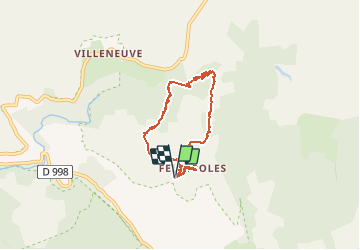

Length
7.8 km

Max alt
1308 m

Uphill gradient
175 m
Km-Effort
10.2 km

Min alt
1168 m

Downhill gradient
176 m
Boucle
Yes
Creation date :
2020-06-29 09:45:23.704
Updated on :
2020-06-29 15:53:10.248
4h01
Difficulty : Very easy

FREE GPS app for hiking
 SityTrail
IGN / Geographical institutes
SityTrail Plus
The world is yours!
About
Trail Walking of 7.8 km to be discovered at Occitania, Lozère, Pont de Montvert - Sud Mont Lozère. This trail is proposed by christineb.
Positioning
Country:
France
Region :
Occitania
Department/Province :
Lozère
Municipality :
Pont de Montvert - Sud Mont Lozère
Location:
Le Pont-de-Montvert
Start:(Dec)
Start:(UTM)
562880 ; 4911999 (31T) N.
Comments